Trail Walking Les Orres - 2024 06 22 Les Orres col de Girabeau - Photo

2024 06 22 Les Orres col de Girabeau

© OpenStreetMap contributors
Length
Length
6.2 km
Max alt
Max alt
2506 m
Uphill gradient
Uphill gradient
690 m
Km-Effort
Km-Effort  
15.4 km
Min alt
Min alt
1810 m
Downhill gradient
Downhill gradient
685 m
Boucle
Boucle
Yes
Creation date :
2024-06-22 06:01:18.858
Updated on :
2024-06-22 17:28:03.539

(0 Reviews)

Walking
Walking
3h30
Difficulty : Difficult

Scan this QR Code to open this trail in the SityTrail application

FREE GPS app for hiking

Logo SityTrail SityTrail

IGN / Geographical institutes

Download SityTrail from the App Store Download SityTrail from Google Play

Logo SityTrail SityTrail World

The world is yours!

Download SityTrail from the App Store Download SityTrail from Google Play Download SityTrail on Huawei AppGallery

About

Trail Walking of 6.2 km to be discovered at Provence-Alpes-Côte d'Azur, Hautes-Alpes, Les Orres. This trail is proposed by Chocard-contemplatif.

Description

seul, sortie RSPG prévue le lendemain, la pluie aussi
grand beau le matin, petite pluie prévue l'après midi
départ de Gap à 7h30 et retour à la voiture à 11 h 35
jolie rando après les grosses pluies
très gros torrent
flore intéressante sans plus
grosse accumulation de bons-henri autour des bergeries

Elevation profile

Positioning

Country:
France
Region :
Provence-Alpes-Côte d'Azur
Department/Province :
Hautes-Alpes
Municipality :
Les Orres
Location:
Unknown
Start:(UTM)
310356 ; 4930287 (32T) N.

Trails nearby

Trail Walking Crévoux - La Cascade de Razis - Photo
Walking
tracegps

Walking

Medium
(5)
Crévoux, Provence-Alpes-Côte d'Azur, Hautes-Alpes, France
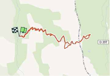
7.2 km | 11 km-effort
3h 30min
Yes
Trail Walking Les Orres - le pic de Boussolenc par la tête du vallon Rémollon - Photo
Walking
GUIDE
amiral13

Walking

Medium
(1)
Les Orres, Provence-Alpes-Côte d'Azur, Hautes-Alpes, France
7.7 km | 13.7 km-effort
4h 50min
Yes
Trail Walking Crévoux - PARCOURS DES FEES #7 - Photo
Walking
CAMBON

Walking

Medium
(1)
Crévoux, Provence-Alpes-Côte d'Azur, Hautes-Alpes, France
8.3 km | 11.6 km-effort
2h 35min
Yes
Trail Walking Les Orres - 2012-08-10_Sentier du garde - Photo
Walking
Tchoubi

Walking

Medium
(1)
Les Orres, Provence-Alpes-Côte d'Azur, Hautes-Alpes, France
11.3 km | 17.6 km-effort
4h 6min
Yes
Trail Mountain bike Les Orres - Les Orres 1800 - Savines le Lac - Photo
Mountain bike
tracegps

Mountain bike

Difficult
(1)
Les Orres, Provence-Alpes-Côte d'Azur, Hautes-Alpes, France
28 km | 42 km-effort
3h 0min
No
Trail Walking Les Orres - l'Aupillon - Photo
Walking
GUIDE
amiral13

Walking

Difficult
Les Orres, Provence-Alpes-Côte d'Azur, Hautes-Alpes, France
16.8 km | 33 km-effort
7h 43min
Yes
Trail Walking Les Orres - le Pouzenc - Photo
Walking
GUIDE
amiral13

Walking

Difficult
Les Orres, Provence-Alpes-Côte d'Azur, Hautes-Alpes, France
14.6 km | 31 km-effort
7h 41min
Yes
Trail Walking Les Orres - les orres 1800 . lac sainte marguerite / montée par le sentier et retour par la piste - Photo
Walking
GUIDE
stef789

Walking

Easy
Les Orres, Provence-Alpes-Côte d'Azur, Hautes-Alpes, France
10.2 km | 18.2 km-effort
3h 59min
Yes
Trail Walking Crévoux - Sentier des Fées Crevoux 16/08/18 - Photo
Walking
GUIDE
R@ph

Walking

Easy
Crévoux, Provence-Alpes-Côte d'Azur, Hautes-Alpes, France
6.1 km | 9 km-effort
1h 52min
Yes


Close
My subscriptions